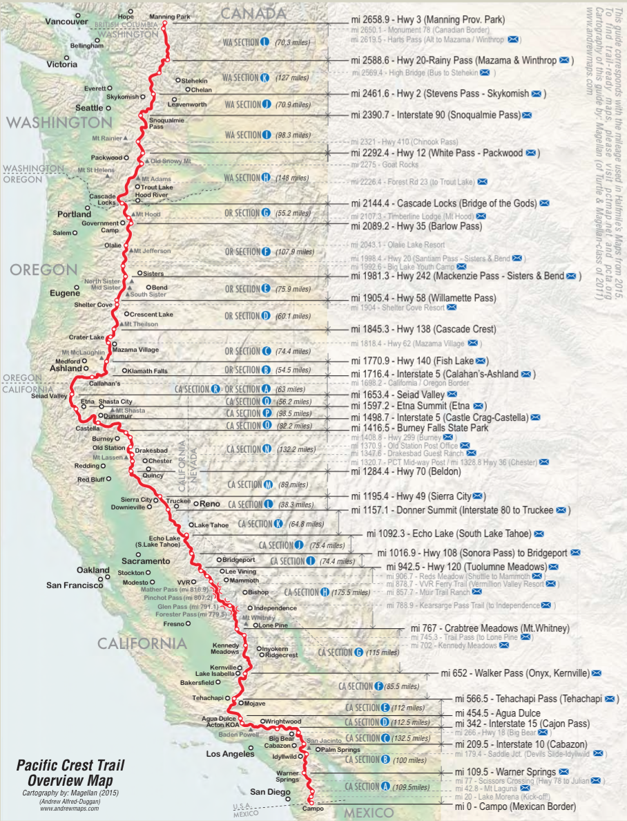
The Pacific Crest Trail stretches from the Mexican border in southern California all the way to the Canadian border in northern Washington. En route, it covers more than 2,650 miles, from low deserts to the highest mountains.
The trail begins just outside Campo, California, on the Mexican border (yes, you can touch the border wall). Nearly everyone starts sometime between late March and early May: if you start too early, you run into deep snow in the High Sierra in California and can’t cross; if you start too late, you can’t make it to the finish before the big snows come in northern Washington. The trail ends at the Canadian border, in Manning Park, British Columbia.
You can divide the trail into roughly four stretches:
- The California Desert is the first 700 miles or so, starting at the Mexican border and ending at a place called Kennedy Meadows. The trail makes a large “C” shape to avoid the very worst of the desert (think Death Valley), but it’s still extremely hot and dry. Yet it also gets very mountainous: the trail summits San Jacinto Peak, which is 10,800′ and can get significant snow at times. This stretch of trail will probably take us the first month or so, from early April until mid-May.
- The High Sierra is about the next 500 miles, and is widely regarded as the most spectacular part of the entire trail. It approaches Mt. Whitney, the highest mountain in the continental U.S. (which we may well summit again), follows the John Muir Trail (which we hiked three years ago) for most of its 220 miles, and rambles through incredible peaks, valleys, passes, lakes, and streams. We’re likely to take about another month here, from mid-May until mid-to-late June.
- Northern California and Oregon is where you really put on the miles: this nearly 1,000-mile stretch has lower mountains and gentler terrain, and 25-to-30 mile days are common. Unfortunately, this is also where the mosquitoes are most likely to become truly maddening — but we’re prepared for that. This will likely take us from mid-June through early-to-mid August.
- Washington State is the last great hurrah: nearly 500 miles of spectacular hiking through the Cascades, mountains that everybody says are incredible but which I’ve never seen. Your pace gets a little slower as the terrain gets rougher, but it’s also incredibly beautiful. We might even encounter a little snow here, as we’re here from mid-August through mid-to-late September.
We’ll be averaging about 20 miles per day of hiking over the course of six months. About once a week, we plan to take a “zero” — come into town one evening, get a hotel for two nights, and spend a day taking long showers, doing laundry, relaxing, and, oh yeah, eating.
Leave a Reply