Today, I felt like more of a hiking badass than ever before on this trip, or even in my life. We climbed the tallest mountain in the continental U.S. through snowfields and ice on rocky ledges, hiked for 15 hours straight, and walked 23 miles while ascending and descending over 5,000 feet each. As Bucket aptly noted, at 5 AM we were at an elevation of 9,580′; at 3 PM, we were at 14,505′; at 8 PM, we’re at 10,741′. I’m as exhausted as perhaps I’ve ever been, and the day was just insane, but it’s also been a massive achievement.
It all started at 4:00 AM this morning, when we woke up to start our trip. We were camped six miles away from the PCT cutoff to Mt. Whitney, and wanted to get a really early start so we could still summit the mountain. Fording a creek at 5:00 AM tends to wake you up awfully quickly — think of pouring ice water on your feet right after you get out of bed — and so we were off. Six miles isn’t far at all to us these days (isn’t that kind of crazy?), so we got where we needed to be by shortly after 8:00.
Mt. Whitney isn’t actually on the PCT; rather, it’s a roughly eight-mile side trip from it. This meant we could effectively do it as a day trip, with “day packs”: we left the vast majority of our gear in bags at Crabtree Meadows, a “base camp” for Mt. Whitney, and set out with only the food and supplies we needed for the day on our backs. Mind you, this still meant a roughly 15-pound pack, but it was a whole lot easier than had we gone up in full pack.
We’ve been up Mt. Whitney once before, in 2012, at the conclusion of our hike of the John Muir Trail. I’m not sure if knowing what lay ahead of us made it any easier, or not: Mt. Whitney is a seriously difficult hike no matter how you do it. It starts out easy enough, with a few miles through ascending (beautiful!) alpine lake basins…but then quickly gets much, much harder. As it turns out, hiking Mt. Whitney in early June is very different from hiking it in late August — because snow. And because ice, and cold.
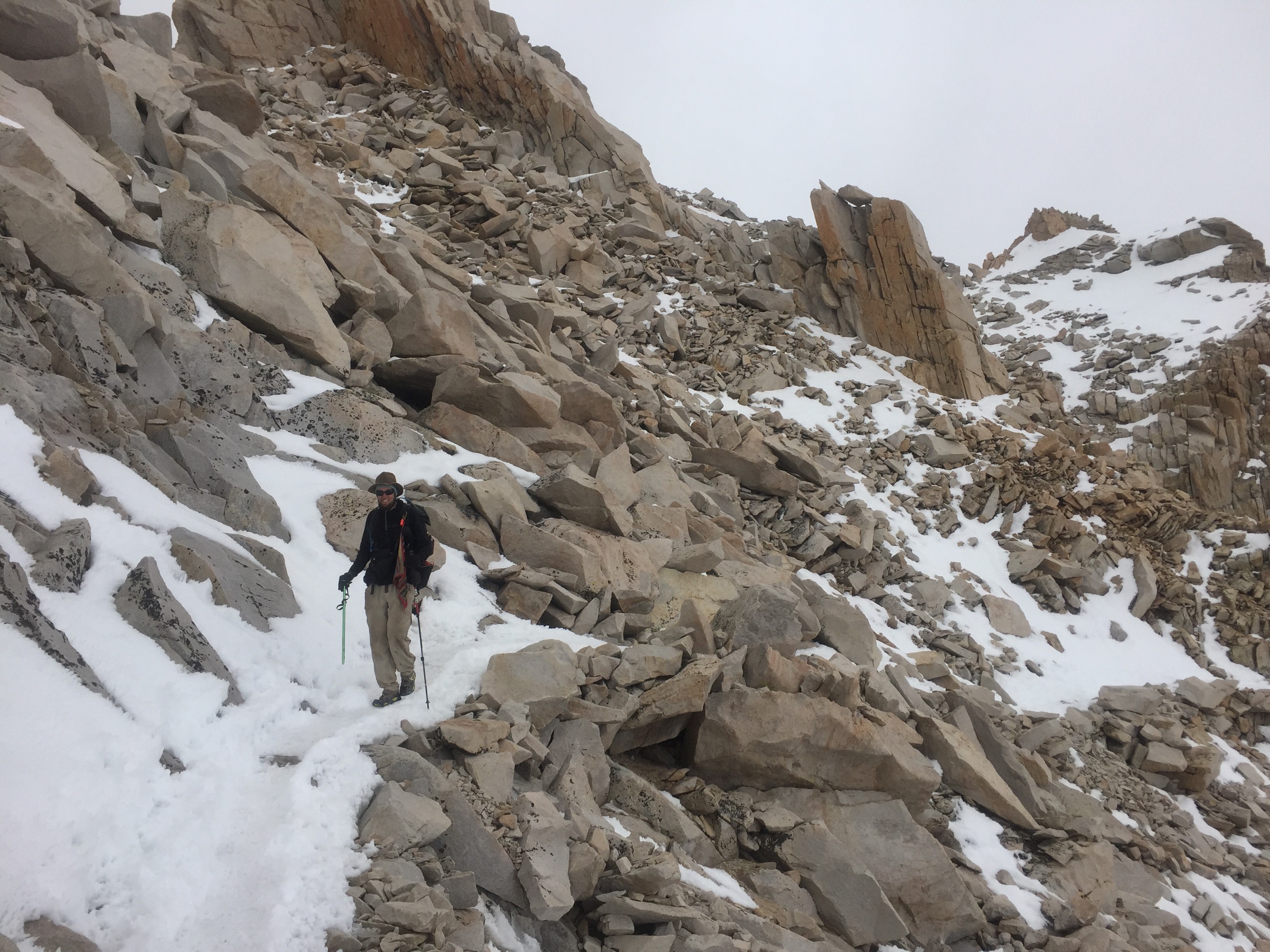
The endless switchbacks are the first hurdle: you ascend roughly 1,700 feet over a few miles while switchbacking over and over across a steep, barren rocky mountainside. It’s slow going, with you having to watch every step while huffing and puffing because you’re climbing so hard (and because there’s very little oxygen at 13,000 feet!). And then the snow starts. Around 13,200′, you start coming across snowfields that cross the trail, each one making footing treacherous and your balance crucial. (Depending on the snowfield, a slip could mean either feeling clumsy and getting back up…or sliding a few hundred feet onto boulders, with resulting catastrophic injury or death.)
We were glad we brought ice axes, and even more glad that we’d taken a three-day course that taught us how to use them. With a trekking pole in one hand and an ice axe in the other, we carefully made our way across the snowfields and then up the remaining switchbacks. At 13,800′ — over four thousand feet higher than we’d started the day — we hit Trail Crest, the junction of Mt. Whitney’s western and eastern approaches. From here, it was only 1.9 miles and about 600 feet of ascent to the summit.
That should really say “only” 1.9 miles, because it really feels like you’re only halfway there. Not only does the snow become a near-permanent fixture at that elevation, but the trail quickly shifts. Where you used to be switchbacking up a mountain, now you’re hugging incredibly tightly to the side of enormous pillars of stone. Wrapping around them over and over on paths that aren’t all that wide to begin with, the snow makes it a whole different adventure. We plunged our ice axes deeply into the snow on the mountainside for support, and used our trekking poles for balance on the other side. Slowly, slowly, slowly we made our way around and around the pillars, and finally came out onto the homestretch.
I should pause for a moment here and be clear: it’s not as if anything we did was stupidly dangerous or something we felt we couldn’t handle. We’re above all prepared and cautious hikers, and we never pushed ourselves into anything we didn’t feel like we could do. Our ice-axe training and snow course helped our confidence and skills enormously. At the same time, I’ve never done anything so daring before, nor felt like as much of a badass as I did climbing that mountain. (An exhausted badass, to be clear.)
The homestretch up to Mt. Whitney is a long, slow climb across more rock faces. It’s the kind of climb that wouldn’t be difficult if it were on a dirt path at sea level, but which feels incredibly draining when you’re up there above 14,000′ and have been hiking for many hours already.
We were almost at the summit! But…as we’d been ascending, the weather we’d seen slowly developing got more and more intense. We knew they weren’t storm clouds or going to make our climb genuinely dangerous, but, as we approached the summit, the clouds covered the top of Mt. Whitney completely — and started snowing on us. So that’s how we found the top of the tallest peak in the U.S. outside of Alaska: very cold, snowy, and with a view of…clouds, clouds, and more clouds. We could see back the way we came reasonably well (and the views were amazing), but the incredible view down the eastern side of the Sierra, into Nevada, was just completely blocked.
Did we stay long on top? Hell, no, we didn’t. It was about 33°, windy, snowing on us hard, and cloudy everywhere. We took a few pictures, signed the trail register, tried to text Treeman and Hedgehog (amusingly, there’s some cell-phone service on top of Whitney, although not enough to actually work today, apparently), and then headed straight down.
As any hiker knows, descending from a summit like that isn’t exactly a piece of cake, either. Not only do you have to do absolutely everything you just did all over again, but this time you’re a lot more tired — and colder, because your body is no longer generating tons of heat from climbing. Your mind wants to wander, because it’s slightly bored (there’s no novelty on the trail any more), because there’s no longer the excitement of reaching the top, and because it’s sick of hiking…but you can’t let it: most accidents happen on the return trip for these very reasons, and this wasn’t a place to let our guard down. We slowly picked our way across the homestretch, across the pillars of rock, made it to Trail Crest, and back down all those zillions of switchbacks, over and over and over again.
The last few miles today were some of the most exhausted I’ve ever been while hiking. It’s as if I entered an altered mental state: I almost started seeing things in the trees, time seemed to alternately stretch out and pass very quickly, and all I could do was to keep putting one foot in front of the other. The hiking itself did not seem to pass very quickly, though, and it felt as if the last two miles took several hours by themselves.
I can’t explain how good it felt to get back here, to Crabtree Meadows, where all our gear is, and be able to set up camp. There are easily twenty-five tents here — this is a hugely popular base camp for Mt. Whitney — and almost everybody has been asleep for an hour. We didn’t get in until almost 8:15 PM, which probably sounds like “evening” to most folks, but which is extremely late for hikers. We were careful to set up camp and make dinner while making as little noise as humanly possible.
And now, finally, we can sleep. I can scarcely even believe everything we’ve done today…and I also think I can sleep for another 24 hours straight.
[alpine-phototile-for-flickr src=”set” uid=”44265343@N00″ sid=”72157654127021466″ imgl=”flickr” style=”gallery” row=”5″ grwidth=”800″ grheight=”600″ size=”500″ num=”30″ shadow=”1″ border=”1″ align=”center” max=”100″]
Leave a Reply