Even if you don’t normally look at the photo gallery I add to the end of every post, take a look at this one. (Hover over one to see a bigger version; click or double-click to go to Flickr, to see the full-size version.) Some days the mountains make you hold back, like yesterday — and some days they let loose every bit of glory they could ever have, like today.
Today, we reached the highest point on the entire Pacific Crest Trail: Forester Pass, at 13,153′. If you look at the first photo above, it’s actually the lowest part of the mountain, just left of center — you know, the point where it looks like it must be impossible to actually climb up. And everything today was so spectacular because of exactly one thing: the weather. It hailed on us last night, then cleared off; today we woke up with sunshine, got snowed on, had beautiful partly-cloudy weather (that was far more amazing than sun alone would’ve been), watched storms roll in, sat under hail, then rain, then snow, watched it clear off, then got socked in with some of the foggiest, coldest weather we’ve had yet…then watched a beautiful sunset. The fact that we walked twenty-two miles is cause for some of that — but, more than that, the mountains just give it all to you. I’m in awe and so content right now, even as I’m unbelievably tired.
After our early camp yesterday, we had no idea what to expect. We woke up early, ready to go after Forester, to beautiful, sunny skies, and started getting ready…but the mountains also have a way of surprising you, and, after 45 minutes, it suddenly started snowing, hard. We thought maybe this was going to seriously delay our day — but, after another 45 minutes, it stopped as quickly as it’d started. As it would turn out, this was the single most propitious event of our entire day. The whole world around us was left with this gorgeous sheen of snow, just deep enough to make everything beautiful and leave our boots squeaking softly in the snow as we walked — but not enough to slow us down one bit. We finished packing up camp, and left.
Some days on this trip, I’ve taken only a handful of photos. One day, I took none at all with my big camera (a Canon EOS 5D Mark III). Today, I took literally hundreds. As we were walking, the sun kept peeking in and out of clouds, casting these amazing splotches of sunlight and shadow everywhere, lighting up the mountains perfectly. We’d stop to take a dozen photos, laugh at how amazing it was, walk another third of a mile…and stop to take a dozen more, because it was beautiful in yet more ways. (I am so grateful that Bucket loves photography, too, because I think anyone else would’ve killed me for stopping so very often. In fact, she is and was just as enthusiastic as I am.) I’ve truly never seen mountains like that before — I remember laughing and yelling that it was just like being in a calendar, because it was so incredible.
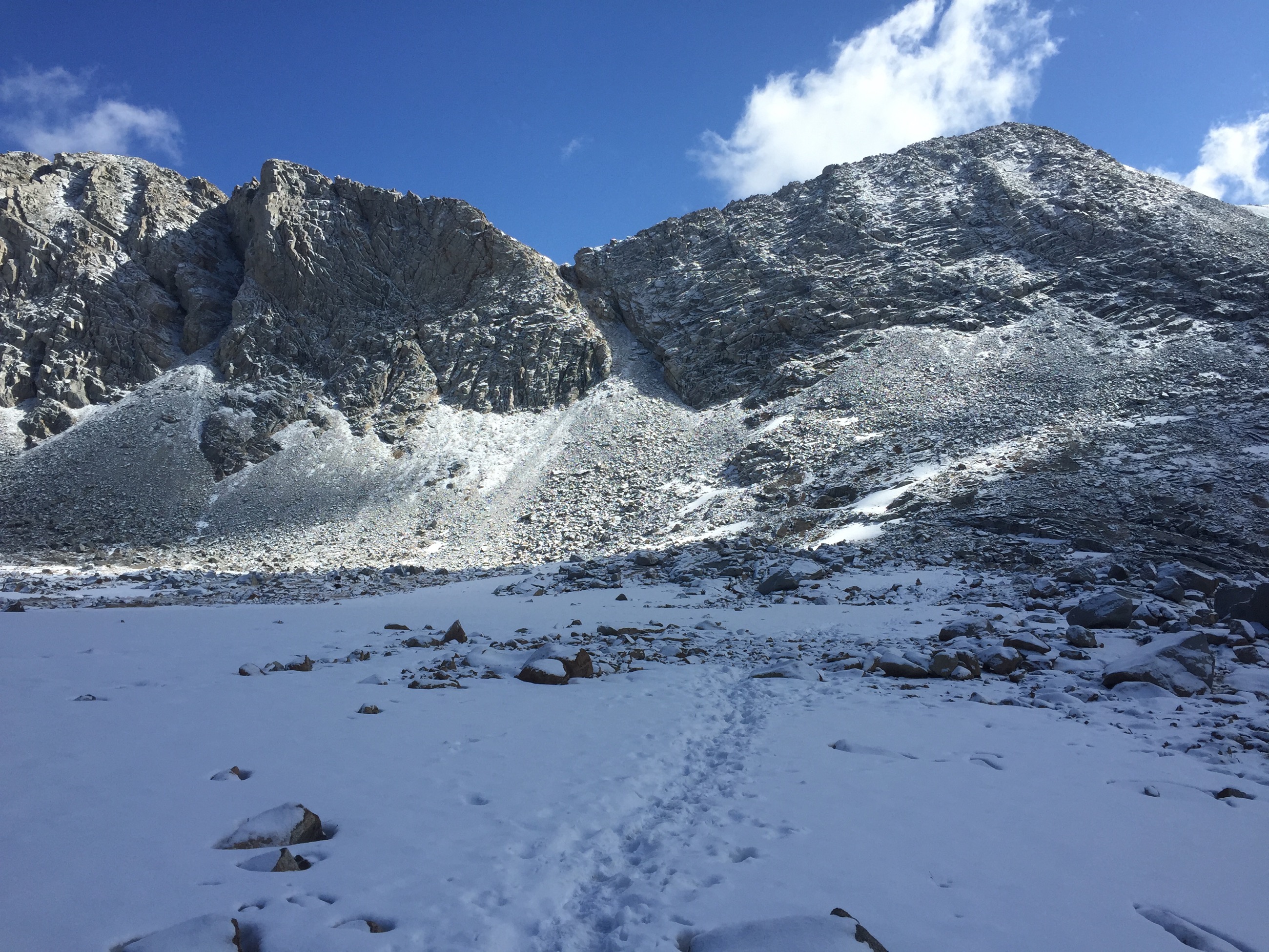
The southern approach to Forester is naturally spectacular anyway; you’re climbing over these vast open, rounded hilltops, one after another, the forest giving way to stands of trees, which in turn give way to open rocky fields, eventually crisscrossed with mountain streams flowing among the rocks. As you climb higher and higher, you can see the pass itself almost the entire time, and it is, in the most literal of senses, incredible: if you pointed to someone and told them where they were going — we’ve been up Forester twice in years past, so we know exactly where it is — they wouldn’t believe you, because it looks so steep and so impossible to climb. Of course, it isn’t impossible to climb, and, while steep, is actually easier than it seems; it just still gives you views and a sense of awe that are unsurpassed anywhere on the trail, as far as I’m concerned. (Even Mt. Whitney, I think, while significantly harder hiking and more impressive in some senses, isn’t actually as rewarding or amazing.)
The final approach to the pass switchbacks up that hugely steep, rocky hillside, over and over, until you finally cross the couloir — and the top is right there. There’s a final, most difficult snowy embankment to scramble up; fortunately, the snow steps are much sturdier than they look, and we were on top rapidly.
When you’re up there, you can see out in both directions for what seems like forever. We could see south, back the way we’ve come, out across ranges and ranges of mountains: realizing you’ve come as far as your eye can see (and much, much farther) is thrilling. We could see north, ahead to where we’re going, out to the peaks, passes, valleys and lakes of the JMT: realizing you’ll go as far as your eye can see (and much, much farther) is humbling and exciting. We had beautiful sunlight on top, chatting with other similarly-thrilled hikers, looking out across everything, until we finally started getting chilly and decided to head down.
For any mountain or pass in the northern hemisphere whose slopes are primarily north-south — as Forester is — the north side will inevitably be considerably colder and snowier, because it doesn’t get nearly as much sunlight. This meant, for us, that while the south side had a little snow at the top and along the path, the north side was fields and fields of open snow for the first mile or two. The trail itself was completely invisible, yet great gullies of snow showed us the path taken by dozens of hikers’ feet before us — perhaps not on the trail itself (because in deep snow, the “official trail” is almost irrelevant), but on a reasonable path down the mountain. We started down, feeling confident that following the same route would prove successful.
And it was, except that we had to watch out for something new: postholing. Postholing is what happens when you walk on deep snow that’s been softened by sunlight and/or high temperatures: step in the wrong place, and your foot can sink not just a few inches, but up to your knee or even your waist. It can cause serious injury at the worst, and makes progress incredibly slow at the best. Because we were following a well-trodden path, we didn’t have to worry about creating new postholes ourselves — but we did have to watch out for postholes created by those who’d walked before us. In some areas, about a third of all the footpads left in the snow were literally feet deep; our eyes stayed constantly looking down, always wary, careful to step only on hardened footprints that were raised high, never falling in. It’s incredibly mentally taxing, and we were very glad when, finally, after a mile or so, we started hitting significant patches of rocky ground instead…and, finally, the real trail.
The approach to Forester Pass on the north side — the side we were now descending — is incredibly long, and eventually seems deeply tedious in a way the southern approach simply doesn’t. While descending it is far preferable to ascending, it still gets frustrating, especially since, when descending, you don’t have a major goal to look forward to the way you do when ascending. Once we hit dirt trail, we moved really fast, flying along the trail…but it still seemed to take just about forever to finally hit treeline, where we’d said we’d let ourselves have lunch. It was such a relief to get there and relax for a bit, having climbed and descended over 2,500′ each.
After lunch, we started down the long canyon that’s the rest of the approach to Forester — but now the weather loomed, dark clouds having formed overhead during our descent. So far, we hadn’t yet had any precipitation since the morning’s snow, and in fact had sunlight for lunch…but now the skies finally opened up — with hail. We’ve found hail to actually be very common on the trail, so far coming down about as often as rain or snow, and, actually, to be probably the preferable form of precipitation. Rain soaks you fast, snow means it’s really cold and can be problematic when it accumulates, but hail — as long as it doesn’t get too big — bounces off you, doesn’t make much wet, and is even kind of fun.
Our hiking umbrellas went up, and it was actually really kind of charming. With the umbrellas up, you don’t have to wear a hood to stay dry, and so we bounced quickly down the trail, our umbrellas keeping us (mostly) dry, hearing the hail fly off the umbrella and scatter in all directions. It was incredibly different from our snow-covered, gorgeous morning, but still a deeply enjoyable part of the day, especially since it took our minds off the sheer length of our descent.
And then…we hit the bottom. The hail had largely stopped, and, although the skies were grey, the weather was no longer the issue. Instead, the ascent was. From the bottom of that canyon, the PCT ascends — steeply. We’d already hiked a dozen miles, up and down over the highest point on the entire PCT, yet here we were, confronted with one of the steepest climbs we’ve encountered yet. We paused, sat on a rock for a bit, gathered our strength…and started climbing.
This section of the PCT is the single longest stretch without a single place to resupply that’s actually on the trail, or accessible by road from the trail. Between Kennedy Meadows, six days behind us, and Vermilion Valley Resort, six days ahead, there really is nothing. Some hikers do this stretch in one fell swoop, packing in as many as fourteen days’ worth of food — which weighs something like thirty pounds, creating a crushing burden on your back.
We, however, did the same thing probably three-quarters of hikers do: we’d decided to hike off the PCT, sideways, over Kearsarge Pass to the Onion Valley trailhead, spending sixteen additional miles of hiking — eight each way — of steep ascent and descent so that we could carry only half the food for each segment, resupplying in one of the gorgeous eastern Sierra towns off U.S. 395.
(Whether you’re a hiker or not, I heavily recommend sometime driving up and down U.S. 395, which I’ve heard called — and I agree with this — “the most beautiful road in America”. It sidles up and down the flat valley just east of the Sierra at only about 3,500′ of elevation, meaning you have spectacular peaks looming over ten thousand feet above you the entire time.)
As a result, we knew that if we were able and willing to pull a bit of an excruciating day — over 22 miles in some serious mountain terrain, including the ascent and descent of Forester — we’d be able to get all the way out to the town of Independence, CA, take showers, eat at a restaurant, and sleep in a real bed…that very evening. If there’s one thing that could inspire us to keep slugging away at that brutal ascent even though we’d already done so much, that was it.
And so we did: we climbed a thousand feet on the PCT, then turned off it onto the Bullfrog Lake Trail, bound for Kearsarge Pass…a full 1,200 more feet above us. At times like this, hiking shifts into something you just sort of keep doing because you’re already doing it: shear perseverance and force-of-will start to become your motivating factors, and you just. keep. doing. it.
That was probably especially good, because the weather turned worse about this time, and, this time, almost for good. We started getting rain this time, worse than hail, and just intermittent enough to mean we couldn’t ever actually take off our raingear or pull down our umbrellas.
We slugged along past Bullfrog Lake, and then really started ascending…just around the time that the freezing fog rolled in. I know for a fact this section of the trail has some spectacular views when you look behind you, and we got a few glimpses of them, but, pretty quickly, we couldn’t see more than a hundred feet behind or ahead of us. The trail was completely socked in with fog, and cold fog; the fact that we were ascending was one of the few things that kept us warm without having to don all our cold-weather clothes.
The top of Kearsarge Pass was, in a sense, spectacular, but not because of what we could see — because we really couldn’t see a damn thing. Instead, it was spectacular because of just how incredibly cold it was; on top of the freezing fog, the wind often kicks up really, really hard at passes, and it chilled us to our bones. And, of course, we were no longer ascending, so all that body heat was no longer warming us up.
Yet we stopped up there, for one reason, and one reason only: after ten days without any cell-phone service, we finally had some. And this meant we could call ahead to Independence to see if we could get a hotel room — the towns on U.S. 395 get packed with tourists in the summer, and this is a Saturday, meaning we’re less likely to get a room than any other night. We had quite a few incredibly fragmented conversations with hotel owners — one after another said “I’m sorry, we’re full tonight”, to our great disappointment — but, eventually, we heard “yes, I do have a room available”. Hurrah!
It was actually another full struggle with calling places next to try to find a ride from the Onion Valley trailhead into Independence. The trailhead is 13 miles from Independence, but, more importantly, nearly six thousand feet of elevation above it — and that means a very long, very windy, and very slow-to-drive road. Because Independence was so busy, and because we were calling on a Saturday night, finding a ride was nearly impossible. We called three different folks who’d said they might be able to ferry hikers from the trailhead to town, but all were busy. We kept plunging down the mountain instead, hoping that the owner of the hotel we’d booked, who said she might be able to do it if we couldn’t find a ride any other way, could do it.
It was dusk by the time we got down to the bottom, looking down on campfires from the trailhead campground and dozens upon dozens of parked cars in the lot — presumably for all the folks who’d gone camping in the backcountry for the weekend. Alas, none of them at all left during the long time we could see them as we hiked down, leaving us little hope of hitching. But, once we got there, the owner of Ray’s Den motel came through! We called her, she got someone to cover the front desk…and about 45 minutes later, in the now-cold-and-dark, an old pickup truck showed up and she hopped out! Hurrah! Given that we’d been sitting by the outhouse in the cold, dark night for nearly an hour, we were incredibly happy to see her.
You meet all sorts of interesting people in your interactions on a trip like this. Turns out our driver and hotel owner was a former ranger for the California State Parks who’d gotten really sick of her boss about ten years ago and decided she really wanted to be her own boss. Her parents lived just up the road from Independence, in Bishop, and when she passed through one day, she saw that Ray’s Den was for sale…really, really cheap. She put in an even lower bid, they took it, and — she’s been her own boss for ten years, living in this small town, making it work with her motel. She was a kindred spirit in many ways, spending much of her time hiking and her truck festooned with liberal bumper stickers; needless to say, we liked her a whole lot, as well as being incredibly grateful to her.
And now, safe in our hotel room in Independence, we’re so unbelievably happy. This morning doesn’t even seem like it could possibly have been this morning, it feels so long ago. After 22 miles, we don’t care that all both of the restaurants in town are closed — we’re just really, really glad to be someplace warm, with a shower and a real bed, and absolutely no hiking to do tomorrow.
Days like this are one of the great, great things about hiking. They may be exhausting, they may be crazy, but they make me feel alive, very happy, and connected to the entire world. I love them, and wouldn’t give them up for anything.
[alpine-phototile-for-flickr src=”set” uid=”44265343@N00″ sid=”72157651860840694″ imgl=”flickr” style=”gallery” row=”5″ grwidth=”800″ grheight=”600″ size=”500″ num=”30″ shadow=”1″ border=”1″ align=”center” max=”100″]
Leave a Reply to AndrewCancel reply